50-51, Grand Canal Townlands East to West: Derries to Glyn No 50-51 in the Grand Canal Offaly Series. By Philomena Bracken, Offaly History

With the construction of the Grand Canal from the late 1750s, brought with it the expansion of Trade. goods could be carried from East to West along the line, this helped boost the development of the local economy from the late 18th century. The Offaly section of the canal runs approximately 42 miles and is home to a number of species and wild plants, due to the cross over through wet bog land during the development of the canal way[1].

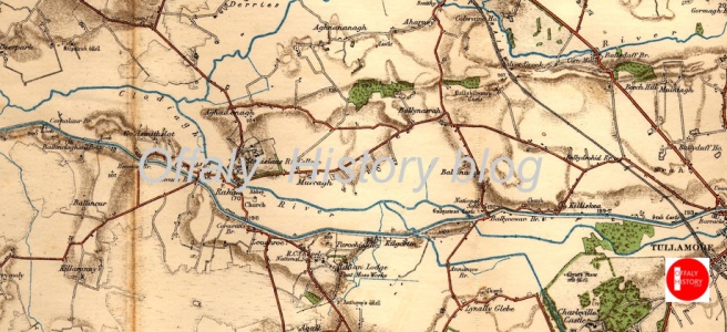
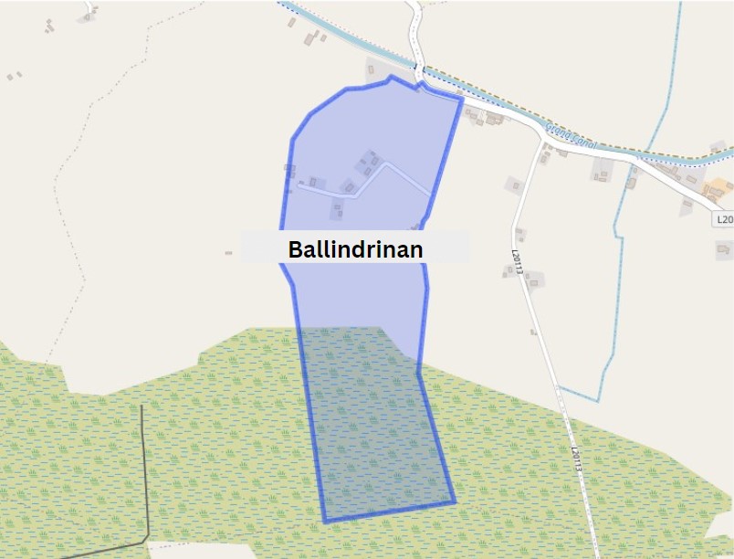
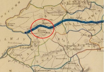
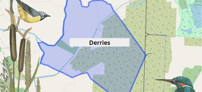
 The first townland we come to along this way is Derries. It is situated in the Electoral Division of Ferbane, in the Civil Parish of Wheery or Killagally, in the Barony of Garrycastle, in the County of Offaly. The Irish name for Derries is Na Doirí meaning The Oak Woods.

Derries townland map. Image Source: Townlands.ie / Illustrations Nature on Irish Canals by Paul Francis

Wheery or Killagally is a large civil parish and it extends about 7 miles from Pollagh Village.

Continue reading

‘Altogether, Tullamore was voted an excellent destination’.  A visit to Tullamore and district in September 2023 by Michael Fewer

In April 2023 our little history group had a successful trip to the town of Wexford, where it was decided that our next outing would be Tullamore. So, on 28 September, we came together for lunch in the bar of the Bridge House, of which I have fond memories of getting warm and dry after a trek in driving rain from Daingean during my walk across Ireland in 2001, before checking in to our bed and breakfast accommodation at the Sea Dew guesthouse.

After lunch we took a walk up the town to have a look at the Offaly History Centre owned by the Offaly Historical and Archaeological Society. It is a very impressive facility indeed, an extensive premises just chock-a-block with books old and new, collections of records of all kinds, bound newspapers, photographs, family papers, school records – the list goes on and on. Michael Byrne had been introduced to me by Fergal McCabe: Fergal’s watercolour works are everywhere there.

Continue reading

48-49, Grand Canal Townlands East to West: Pollagh to Turraun No 48-49 in the Grand Canal Offaly Series. By Philomena Bracken, Offaly History

Pollagh also spelt as Pullough, is located in a small village in County Offaly, it is in the Civil Parish of Lemanaghan. A small parish, it extends from Ballycumber to Ferbane. Pollagh village can be found on the north side of the canal. The Parish lies in the territory of Dealbhna Eathra of the MacCoghlans – an ancient people. It has a rich heritage in its archaeology including the important monastic site, churches, and ringforts and the famous castles.

One of The townlands that we come along as we work our way down the line is Pollagh, the name in Irish is Pollach, meaning Place full of Holes.

TownlandAreaPop in 1841Pop in 1851No. of Houses in 1841No. of Houses in 1851Pop in 1871Pop in 1911No. of Houses in 1871No. of Houses in 1911
Pollagh907 26716843332822234250
An interesting profile in the fall and rise of the population due one assumes to the successful brick industry.
Continue reading

Renewing your subscription to Offaly History (Offaly Historical and Archaeological Society) for 2024: a gentle  reminder to Canon Stubbs, the Regius Professor of Modern History at Oxford, in regard to his membership subscription due to the Hellenic Society, in 1882. Joining OHAS in 2024.

A recent purchase by a ,member of Offaly History of the Letters of William Stubbs (1825-1901), edited by W.H. Hutton included an original letter from the Hon. Secretary of the London-based Society for the Promotion of Hellenic Studies sending a gentle reminder to the  learned and revered historian that his subscription was outstanding for four years. i.e. from when that society was formed in 1879. This sometimes happens in Offaly History too, when perhaps a distinguished member will forget to renew and one would not have the temerity to send a reminder. Not so the Hellenic Society.

Continue reading

46-47, Grand Canal Townlands East to West: Ballindrinan to Cornalaur No 46-47 in the Grand Canal Offaly Series. By Philomena Bracken, Offaly History

Rahan, Civil Parish is situated in the ancient O’Molloy territory of Fear Ceall meaning Men of the Woods or Men of the Churches. It is bounded on its north west side by the Brosna River. Its bedrock is Limestone and it has deposits of brick and clay along the Grand Canal.

The townlands from Ballydrohid, Tullamore to Cornalaur
Ballindrinan Townland/ Image Source Townlands.ie

Its best know archaeological site is the Rahan Monastic Centre which was an area of great importance in the early Christian Period.

Townland: Ballindrinan is in the Electoral Division of Rahan, in Civil Parish of Rahan, in the Barony of Ballycowan, in the County of Offaly.

The Irish name for Ballindrinan is Baile an Draighneáin meaning land of the blackthorns.

Continue reading

The Boarding School in Ferbane and the impact of the sisters of Saint Joseph of Cluny on the Midlands of Ireland. By Mary Delaney

The sisters of Saint Joseph of Cluny first arrived in Ferbane on the 12th of May 1896. Their arrival and the arrival of those who followed in their footsteps were to have a significant impact on the community of Ferbane and to the education of young women in the midlands of Ireland.

The order of Saint Joseph of Cluny was founded in France in 1807 by Blessed Anne-Marie Javouhey. Having grown up in the aftermath of the French Revolution, her dictum was “to love the children” and make a great effort to improve their education to as high a degree as possible”.

“We have been asked to go to Ireland, to teach the poor and the well to do. I have been assured that we could do much good there. If such be the will of God, I agree to this foundation with all my heart”.[1]

Blessed Anne Marie wrote the above in 1850. However, it was ten years before four sisters, led by Mother Callixte Pichet, arrived in Dublin, and set up residence in a former Carmelite monastery in Blanchardstown. The congregation grew and within a year, twenty-three Irish girls had joined the order. The community continued to expand and in 1864 the sisters established their first secondary school for girls at Mount Sackville, situated in the idyllic location above the valley of the river Liffey adjoining Dublin’s Phoenix Park.

Mount Sackville would take its place among the leading secondary schools in Ireland and continues to be synonymous with the education of young women 160 years later.

Continue reading

45 The landscape of east Offaly: Croghan Hill and Clonsast. Frank Mitchell describes the landscape of east Offaly taking in Croghan Hill and Clonsast bog. No. 45  in the Grand Canal Offaly series

Frank Mitchell (1912–97) was a distinguished but unassuming academic, environmental historian, archaeologist and geologist. While he had many academic writings his best known book was The Irish Landscape (1976) about which he was typically modest. In 1990 Mitchell published ‘a semi-autobiography’ The way that I followed. The title was a play on Robert Lloyd Praeger’s, The way that I went (Dublin, 1937). Praeger in his peregrinations was less kind to Laois and Offaly than Mitchell with Praeger’s observation that neither county need detain us long (p. 235) and ‘there is not much of special interest’ (p. 237). Westmeath he found to be more hospitable than Offaly having less than half of the amount of bog in Offaly and more pasture. We may look at the Praeger account in another blog

Continue reading

AN AWKWARD SITE- The Building and Rebuilding of the Church of the Assumption of Our Blessed Lady, Tullamore. By Fergal MacCabe

A New Church

Towards the end of the 19th century the 1840 Mercy Convent with its frontage to the landscaped banks of the Grand Canal, was the most prominent symbol of the increasing importance of the Catholic Church in the spiritual life of the people of Tullamore. In contrast, the almost one hundred year old St Mary’s Parish Church, which had a capacity for 500 worshippers at most, was of a modest character. Located on a backland site behind Harbour Street on lands gifted by Lord Charleville it shared its cramped accommodation with the Parochial House.

The old church of 1802 to 1903-4

As Michael Byrne records in his comprehensive historical survey of Tullamore Catholic Parish, the question of repairing the old church arose in 1897 but on the advice of the influential businessman and local politician Henry Egan, it was felt that building an entirely new church would be a better option.

No time was lost and on the 16th January 1898 a preliminary meeting of a Parish Council to plan for the new Church was assembled and six days later appointed the Cavan based architect William Hague whose brief was to provide a 1,600 seat structure with additional space for 500 more on special occasions.

Continue reading

Swimming pool opened in Tullamore in 1938 together with O’Molloy Street housing scheme. Damien Byrne

Thursday May 19th 1938 was a big day in Tullamore. The occasion was the opening of 146 new houses on O’Molloy Street and the opening of a new outdoor Swimming Pool by the Tánaiste and Minister of Local Government and Public Health Mr. Sean T. O’Kelly. By Damien Byrne

The local newspapers of the day describe the town as being “profusely decorated with flags and bunting” with O’Molloy Street being “richly festooned with the Tricolour being strongly in evidence”.

The Tánaiste on his arrival at Tullamore, at 12:15 p.m., passed through a guard of honour of Civic Guards, drawn up outside Hayes Hotel. He was met at the door of the hotel by the members of the Council and public officials, and proceeded at once through Patrick St., Kilbride St., and Clara Bridge, where his arrival at O’Molloy Street was awaited by many clergy of all denominations and representatives of the laity. Along the route large numbers of people had gathered, and the Tánaiste smilingly bowed his acknowledgements of their greetings.

Continue reading

43-44 Grand Canal Townlands East to West: Kilgortin/Killina/ Loughroe. No 43-44 in the Grand Canal Offaly Series by Offaly History

Kilgortin is in the Electoral Division of Rahan, in Civil Parish of Rahan, this parish is situated in the ancient O’Molloy territory of Fear Ceall meaning the mem of the woods or men of the churches. If you look closely along the line in this area you will see deposits of brick clays along the Grand Canal between Ballycowan and Rahan, this was the source of an energetic brick industry in the past.  In this part of Rahan you will find the site of Rahan Monastic Centre, this is the most famous archaeological site in this location. It was a very important aspect of Early Christian period.

Continue reading